-40%
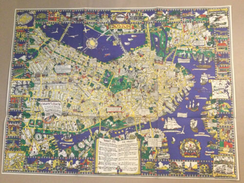
1926 Houghton Mifflin Old City Map Of Boston Color
$ 660
- Description
- Size Guide
Description
1926 Houghton Mifflin Old City Map Of Boston Color. Map and the original envelope Shipped with Priority Mail with additional insurance.It measures 28 1/2 by 37 1/2 inches with small margins. It is entitled THE COLOUR of an OLD CITY.
The map is in great shape. The folds are original and there are no tears, rips or fatigue. There are pinholes in each of the four corners. Please see back of map photos. They are difficult to see from the front. The envelope has some issues. One side is ripped and there are tears on the other, the flap is torn and damaged. There is tape on the back side. The colors on the envelope are bright, and could be framed in its own right, as the damage does not take away from the artwork.
Designed, drawn and coloured by Edwin Olsen and Blake Clark, The COLOUR of an OLD CITY[:] A map of Boston decorative AND historical. Boston: Houghton Mifflin, 1926.
This charming map of Boston was the product of the collaboration of Blake Everett Clark (1900-1979) and Edwin Birger Olsen (1902-1996), two young American draftsmen & architects. In the mid-1920s, they came together to this map and similar pictorial maps of Philadelphia and Washington D.C., all published in 1926 by Houghton Mifflin Co. According to Stephen Hornsby’s Picturing America, work on the Boston map began in September 1925 and entailed six months of “exhaustive study and incessant sketching,” with much research being undertaken in the Boston Public Library & Boston Athenaeum. Houghton Mifflin’s publicity described it as “a model of excellence in this quaint & contemporaneously popular decorative art,” and it proved an immediate success. It is also something of a landmark, as one of the first separately published color-printed pictorial maps to be published in the United States Clark and Olsen’s map includes the core of downtown, roughly from Massachusetts Avenue east, and encompasses the Charles River with parts of Cambridge and Charlestown, as well as the Harbor, Fort Point Channel (“South Bay”) and part of South Boston. The borders are embellished with vignettes depicting historic scenes, buildings and monuments. Boston’s coat of arms appears at top center, while six inset historical maps and views depict the city and its environs at different points in its history. Biplanes swarm above the Charles while numerous vessels ply the vibrantly-colored surrounding waters. Lyrical quotations praising the city dot the map, while an open book at lower center displays a ditty entitled “What It’s All About!” The map’s title appears on the sail of an incongruous Norse longboat floating above Albany Street… perhaps a homage to persistent theories that the Norse had visited the Charles River centuries before the arrival of the Puritans.
Please ask all questions before bidding including additional pictures if needed.
